Roman Road - Cercedilla.
This route covers the best preserved Roman road linking Madrid with Segovia. It leads to Puerto de la Fuenfría, where several roads converge. This Roman Road allowed to link this route with other routes such as El Camino Schmid, the GR 10, and from there to many others: such as El Picode Majalasana.
These roads were built by the Romans, and they were the only system of effective communication channels for nearly two millennia. In fact, there are sections which have persisted to this day, either from its construction or its renovation since its post-Roman Empire times.
The Romans demonstrated a good knowledge of the geography of the land spanning both to search for ports that should give step through mountain ranges to use natural paths opened by rivers. Such is the case of this causeway, going up the River Venta, passing the Segovia slope of the Sierra de Guadarrama by the Puerto Fuenfría.
This road dates from the first century AD and it was built under the Emperor Vespasian, who united Titulcia (next to Aranjuez town) with Segovia, crossing the Sierra de Guadarrama by the Puerto Fuenfría. Probably he went through Madrid's Casa de Campo, where he headed up Las Rozas and Villalba, Guadarrama, Los Molinos and Cercedilla, and from here to the port following the course of the River Venta.
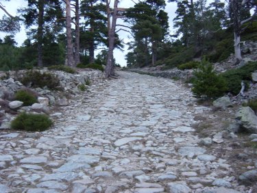
The last part of this route is the best preserved of all roads.
The fact that the road ascends near streams, allows us to observe plant species typical of areas with high humidity, and some of them protected, such as yew and rowan.
The River Venta forced the construction of several bridges: such as the Molino Reajo or under the road that goes to Cercedilla from Los Molinos. Also, bridges called El Descalzo and Puente de Enmedio are located along this route, over streams that flow into the stream of La Venta river.

Route description
Km 0 – The route starts at the car
park in Majavilán. We have to walk north _ crossing a couple of barriers _ until
we reach the special passage for vehicles at the Roman Road
Km 0.3 - Here we can find El
Descalzo Bridge, that stands over a stream that flows downstream the river La Venta. Near the bridge,
we can find La Fuente
de la Salud that
allows us to have a sip of water. From here, the road faces a slope that leaves
the valley formed by the stream on the left.
Km 1 - When we reach the area known
as La Pradera
de los Corralillos, we notice that the road fades for a few meters, but it can
be easily found on the left side of the barrier located there, which also marks
the beginning of the forest track. Now, the stream runs on our right.
Km 2 – The road turns on the left
featuring a beautiful image of the bridge Enmedio over the stream Valle de la Fuenfría. After
the bridge, there is a stretch path, but then, after a sharp slope, we have to turn
the first on the left, that is where the slope becomes much stronger. This
continues until the end of this route.
Km 3.9 - Once we have arrived in Puerto Fuenfría the
way can be linked to other routes to return to the starting point or to follow
the route of the road until Valsaín.

MORE INFO (taken from http://allaboutmadrid.com/what-to-see/cercedilla-roman-road/tab-information):
Cercedilla Roman road is located in the northernmost part Fuenfría Valley, and although most of its layout matches the current road. M-966, superimposed on it, are still visible several sections along a length of 2.25 km. Approx. These remains little tear to the bridge of the sale, on the right side of the road opposite the farm Montesclaros, but not become recognizable until shortly before reaching the bridge Barefoot, which can already be seen that some parts paved - Once through-charge continuity up to the vicinity of Peñalara Chalet, where you lose track at the junction with forest trail to reappear soon after, continuing to exceed Fuenfría port on the edge of the township, extending even beyond, in the province of Segovia.
The visible remains consist of a very poorly maintained paved road, with a variable-width resulting from successive alterations and extensions, between 3.5 and 14 m., And whose construction, but does not have the layers of Roman roads canonical (statumen dry gravel, lime concrete rudus and summa crustaor surface layer formed by slabs with smooth upper face) is very carefully executed, can parangonarse with other routes of the period studied. First lands excavated until a hard coat foundation on which a bed of support prepared consisting of clays and small stones collected in situ, which settled large blocks of granite and gneiss irregular - with an average thickness of 20 cm-forming three longitudinal ribs: two lateral and one central, sometimes with other cross intersect, filling the resultant boxes bands and smaller pieces, also kneeling.
In keeping with the old layout of the road rise four bridges, called the Mill Reajo or from the sale of Barefoot and middle-saving successive points in the Sale River.
Mill Bridge or Reajo. The first, which is the largest of all with a width of about 10 m and a height from the riverbed to sill of 15.4 m, is located on the M-622 from Los Molinos, just before reaching the tunnel under the railroad tracks. It consists of a masonry arch placed in dry-eye with a adovelado formed by large irregular stone slabs Deckle-wedge placed on supporting spandrels of the same material, which acts as permanent shuttering is subsequently filled with masonry concreted with lime mortar. The arch, with a span of 6.5 m, rests on a foundation slightly highlighted vertically reinforced corners d the western-upstream-plant by two semi-hexagonal buttresses that become triangular at the bottom to serve of embankments. These buttresses are repeated in number six on the eastern facade, which help to strengthen the bridge abutments, which extend in a unique wall length built reforming the tunnel under the railway in 1917.
Bridge DescalzoEl second bridge, called the sale for its proximity to the former Santa Catalina sale, has similar characteristics, although the height and light are smaller, with only 5 m, transforming the arc in a barrel vault; may said of the remaining bridges, which, thanks to locate in vacant stretches of the road, still show strong continuity with the original of that, also offering better condition due to recent restorations.
A common feature of all these posts, but especially pronounced in the Barefoot, Enmedio and Mill, is the skew of the vaults support, notably biased with respect to smooth river twists of the road that crosses obliquely. Historians have long speculated about what the port used by the Romans to cross the Sierra: Navacerrada, Fuenfría Guadarrama or because the description section Titulcia-Miacum-Segovia, on the track no. Merida to Zaragoza 24 contained in the Itinerary Antonino-a compilation of all the tracks on the Empire in the third century under the rule of Diocletian, certainly not to locate him. But the appearance in 1910 of a Roman miliario preserved in the National Archaeological Museum, next to the bridge of the Sale, dispelled all doubts, but raised a number of new unknowns, consisting of the first date the initial construction date the road. Blázquez gave a satisfactory solution to decipher the inscription almost illegible miliario: VSPNL QILV - CIDII D. AUG. TRIB. -C. . .... VII, which he interpreted as corresponding to the seventh consulate of Vespasian, allowing the road to give 76-77 years of d. AD, generally accepted view, although the works Fita delayed until the time of Trajan.
In medioMás Bridge is difficult to trace the path of the same, since the locations mentioned in the Itinerary of Antoninus are conflicting location due to the changes in place names since then, without the existence of an error in the description precisely corresponding to this section, which does not correspond to compute the distances described in the text with the actually existing problem that has been solved traditionally sandwiching a mansio or additional sales, Miguel and Eced Cercedilla precisely positioned in the vicinity of the chapel of Santa Maria, where he passed the road after crossing the bridge over the river Matasnos of Bridges. According Blázquez, who studied the route directly on the field early in the century, the road, from Miacum-usually identified as Meaques in Madrid's Casa de Campo - was passing through Las Rozas, Villalba, Collado Villalba, Alpedrete, Guadarrama and Los Molinos before entering Cercedilla following the old casting Matasnos, which reaches the bridge Reajo described above.
The last problem is the dating of the remains we see today, the more difficult issue in that the road has been used continuously since it was built in the first century until the opening of the port of Navacerrada late s. XVIII. In this period occurred continuously reforms and interventions, because since ancient road workers were attached to the maintenance of the road, which, as stated explicitly in the Cadastre of Ensenada in 1752 - was the responsibility of the town of Cercedilla, responsible composition of paths to the steps of the main real people interested in keeping a distance speedy forming the basis of its prosperity.
For this reason, and although most authors admit the authenticity of the preserved sections, Fernández-Trojan-based on certain unusual features of the bridges in the Roman world: skew, rigging, width, presence of buttresses, etc.. - Has questioned the age of the same, considering the product of the reform on the road to 1728 to facilitate access from Madrid the palace of La Granja. In this respect the author argues the existence of another path paved narrow and deteriorated, which sometimes runs parallel to the road above and other disappears under it, and that would match the original Roman.
In 1979, thanks to the tenacity of Michael and Eced, who warned of the delicate condition of bridges and Barefoot-Enmedio decided to restore them by the architect himself Cervantes and Miguel Martinez and Eced; effected the work by the Icona and the Committee on Culture, Sports and Tourism of the Provincial Government. Thus, the dome was rebuilt and repaired first, using a pre-felling of the second, which had a huge sinkhole six feet in diameter, recovering both sills. Unfortunately, archaeological excavations conducted by Mary Mariné occasion of these works did not provide conclusive data on the old road, but allowed the construction system used to know, that can be related to other known Roman roads. New works have been undertaken in 1996, under the supervision of the Directorate General of Heritage Community of Madrid, and in collaboration with the National Institute of Employment-INEM, and the Society of Friends of prehistoric monuments and ancient-SEAMPA -, pretending to recover all known sections of the road, from Galapagar to the province of Segovia.
The road and bridges Cercedilla Roman in 1967 were included in the Inventory of European Heritage-EICP-sponsored by the Committee of Ministers of the European Counsel, proposing his statement as a Historic-Artistic and National Archaeological in 1979, which was filed two years later, finally being approved in 1983.
Situation:
* Calzada: final M-966 Fuenfría port.
* Mill Bridge or Reajo: M-622 (next to the tunnel under the railway)
* Bridge Sell: M-966, km (Pardo estate Bridge)
* Barefoot Bridge: Peñalara Chalet Road (Old Glen Fuenfría)
* Bridge Middle: Roman road (Old Glen Fuenfría)
* Mill Bridge or Reajo: M-622 (next to the tunnel under the railway)
* Bridge Sell: M-966, km (Pardo estate Bridge)
* Barefoot Bridge: Peñalara Chalet Road (Old Glen Fuenfría)
* Bridge Middle: Roman road (Old Glen Fuenfría)
Dates
AD 76-77 Years Reform: h.1728
Barefoot and Bridges Middle: restored in 1979
Source: ARCHITECTURE AND URBAN DEVELOPMENT
Volume VI (CERCEDILLA)
Edition 1999
MINISTRY OF PUBLIC WORKS, PLANNING AND TRANSPORTATION
MADRID-WEST ZONE
Volume VI (CERCEDILLA)
Edition 1999
MINISTRY OF PUBLIC WORKS, PLANNING AND TRANSPORTATION
MADRID-WEST ZONE